 First stop... the National Park...such a beautiful little walk.


 After the walk, I decided to take more of a scenic route back to Cork... stunning rolling hills, cute little towns, beautiful scenery.


 First stop... the National Park...such a beautiful little walk.


 After the walk, I decided to take more of a scenic route back to Cork... stunning rolling hills, cute little towns, beautiful scenery.


Blarney Stone and Castle — The 15th-century Blarney Castle is five miles northwest of Cork (the major city of southern Ireland). The town of Blarney is of no importance and the castle is an empty hulk (with no attempt made to make it meaningful or interesting). It's only famous as the place of tourist pilgrimage where busloads line up to kiss a stone on its top rampart and get "the gift of gab." The stone's origin is shrouded in myth (it was either brought back from the Holy Land by crusaders, or perhaps was part of Scotland's royal Stone of Scone).
The best thing about this lame sight is the opportunity to watch a cranky man lower lemming tourists over the edge belly up and head back to kiss the stone while his partner snaps a photo — which will be waiting for you for purchase back at the parking lot. After a day of tour groups mindlessly climbing up here to perform this ritual, the stone is literally slathered with spit and lipstick.
The tradition goes back to the late 16th century, when Queen Elizabeth I was trying to plant loyal English settlers in Ireland to tighten her grip on the rebellious island. She demanded that the Irish clan chiefs recognize the crown, rather than the clan chiefs, as the legitimate titleholder of all lands. One of those chiefs was Cormac MacCarthy, Lord of Blarney Castle (who was supposedly loyal to the queen). He was smart enough never to disagree with the Queen — instead, he would cleverly avoid acquiescing to her demands by sending a never-ending stream of lengthy and deceptive excuses, disguised with liberal doses of flattery (while subtly maintaining his native Gaelic loyalties). In her frustration, the Queen declared his endless words nothing but "blarney." Walking back, you'll cross a stream littered with American pennies — as if the good-luck fairy can change them into euros.
On my last visit to Blarney Castle, heading back to the tour-bus parking place, a woman behind me asked her friend, "What is the Blarney Stone anyway?" Her friend said, "It's what you kiss when you come to Ireland."
More history on the stone, the ritual, etc can be found on wiki. I highly recommend reading up on it!
http://en.wikipedia.org/wiki/Blarney_Stone
The guy did say that they clean it every 1/2 hour...but I doubt it! haha

Here I go!!!
Check out who gave it a kiss with me!!! Vasco and Nunez!!!

Just outside the Gardens of the Blarney House...look what I found!!!!! A 4 leaf clover!!!!! YAYYYYYY... we took a rest after a nice walk around the gardens, I took a rest on the grass and started a wee search. Not even five seconds after my cousin says, "Well Farida, it looks like the laws of nature are against you today..." WABAM... I find my 4 leaf clover!!!! YAYYYYY!!!!

Circular shape of the table: Medieval tables usually were rectangular, sometimes square, but rarely round. This unusual feature of the Round Table invites symbolic interpretation. Some or all of the symbolic interpretations of the table's circularity can be viewed either in bono (pointing to a positive value) or in malo (pointing to a negative value).
Round Table as symbol of the equality of Arthur's knights. Rectangular tables were used at feasts, and the seating assignments normally reflected the feudal hierarchy. In a royal court, the king and queen and a select group of nobles were seated at a "high table" on a dais, while the other participants were seated at one or more rectangular tables in the hall. Those of higher rank were seated closer to the dais; those of lower rank would be seated further away. The Christmas feast at the beginning of Sir Gawain and the Green Knight uses this conventional seating arrangement. The Round Table, in contrast, seems to subvert the feudal hierarchy with its claims of equality among the knights.
In bono we can imagine a fellowship of knights bonded as equals under the code of chivalry. But the explicit statements of this theme present in in malo, as a negative detail. Wace, in his Brut, writes that Arthur ordered the Round Table to be built in order to resolve a conflict among his knights concerning who should have precedence. This theme is elaborated by Layamon in his Brut: he writes that during a Christmas feast at Carduel in Wales, a quarrel broke out among the knights as to who had precedence, and Arthur ordered Merlin to fashion the Round Table in order to resolve the conflict. The Round Table thus becomes a symbol of pride and contentiousness rather than of equality.
Round Table as a symbol of the world: In the 13th-century Queste del Saint Graal, Malory's source for his "Sankgreall," another interpretation of the symbolism is given. An anchoress tells Perceval: "You are well aware that the world has seen three great tables. The first was the Table of Jesus Christ, where the apostles often ate. . . . After that table there was another built like it and in remembrance of it. That was the table of the Holy Grail. . . After that table there was the Round Table build by Merlin, which was not established without a high spiritual meaning. That it is called 'the Round Table' suggests the roundness of the earth, the spheres of the planets, and the elements of the firmament. . . so that one can justly say that the Round Table means the world.


Kinsale (Irish: Cionn tSáile) is a town in County Cork, Ireland. Located some 25 km south of Cork City on the coast near the Old Head of Kinsale, it sits at the mouth of the River Bandon and has a population of 2,257 which increases substantially during the summer months when the tourist season is at its peak and when the boating fraternity arrive in large numbers.
 Cute little town...
 Fishing town...


Perhaps the best-known historical attraction in Kinsale, Charles Fort, is on the road just beyond Summercove. It is open all year, and regular guided tours are available. Charles Fort is one of the finest surviving examples of a 17th Century star-shaped fort, and much of the construction begun in 1678 remains. The fort has two enormous bastions overlooking the estuary, and three facing inland. Within its walls were all the barracks and ancillary facilities to support the fort's garrison. The fort continued in military use until 1922.
 My cousin and I were given a great historical overview regarding the fort... pretty neato!
Charles Fort (Irish: Dún Chathail) is a star fort located on the water's edge, at the southern end of the village of Summer Cove, onKinsale harbour, County Cork, Ireland.[1] James' Fort is located on the other side of the harbour.
Charles Fort is built on the site of an earlier stronghold known as Ringcurran Castle, which featured prominently during the Siege of Kinsale in 1601. The fort, which is named after Charles II, was designed by the Surveyor-general Sir William Robinson - architect of the Royal Hospital Kilmainham.[2] The fort was built in the 1670s and 1680s to a star fortification design - a layout specifically designed to resist attack by cannon.
The in-land bastions of the fort however are overlooked by higher ground. A fact which was of critical importance when the fort was besieged by the Duke of Marlborough in 1690 during the Williamite War in Ireland.[3] Repairs were made following the siege,[4] and the fort remained in use as a British Army barracks for several hundred years afterwards.
An early lighthouse was established here in the 17th century by Robert Reading.[5]
The fort was relinquished by British forces following the Anglo-Irish Treaty, but it fell out of use after being burned by the retreating anti-Treaty forces during the Irish Civil War in 1922. The complex was named a National Monument of Ireland in 1971[4] and has been partly restored by Dúchas, the Irish heritage service.

 Cuzzo Mikail doing the star formation, the same shape as the fort!
 This is a really well known restaurant I was recommended to eat at by numerous people... and it's my cousin's favorite, so we did!
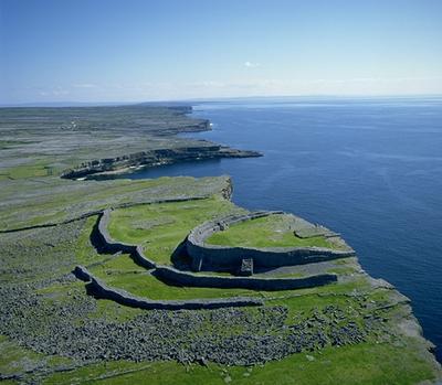
The Aran Islands encompass three thousand years of human history, and one billion years of natural history. Once part of a craggy ridge of limestone that extended from the Burren in County Clare, there is evidence of people living on the islands from as far back as 2300-2000 BC. These early settlers were most likely farmers who came from the Burren and the Irish mainland.
Pirates of the Atlantic..By Medieval times, the islanders lived in "chiefdoms", the largest example of this is the hillfort at Dún Aonghasa on Inis Mór. (The word "Dún" means fort of a king or chieftain). The Aran Island chiefs were powerful and wealthy people who controlled the western sea passages - supposedly keeping the seas free from pirates on behalf of the merchants in Galway in exchange for protection money. But these protectors were apparently not against a bit of pirating themselves!Pilgrim FathersAround the same time (between 800 AD and the early 12th century), there was a frenzy of pilgrim activity in Ireland. The Aran Islands were a very popular pilgrimmage, due to the hardship required to get there in the first place, so suitable penance was endured en route. Each of the three islands have extensive ancient and religious sites worth exploring, including a Bronze Age mound and a "sunken" church on Inis Oírr.Early Bronze Age
It was on Inis Oírr that some of the earliest evidence of civilisation on the Aran Islands was found. Irish legend holds that the Firbolg were the earliest inhabitants of this island having fled to the island to escape invaders.
Cnoc Raithní, is a burial mound which dates back to approx. 2000 BC. During its excavation, some cremation urns were discovered which probably originated in Scotland, so these settlers were well travelled and had connections from far afield.
Early Medieval
Dún Formna is one of the seven stone forts on the Aran Islands. The name literally means "the fort on top of the hill" and it was the home of Inis Oírr's island chieftain sometime after 400 BC. The oval-shaped stone fort now also contains O'Brien's Tower which was built hundreds of years later.
There are three chapels on Inis Oírr, which date back to the 11th century, when pilgrimages to the Aran Islands were at their height - Cill Gobnait, Teampall Chaomháin (now appears to be sunken in the sand) and Cill na n-Seacht Iníon. The patron saint of the Aran Islands is St. Enda, who founded the first monastery on Inis Mór in the 6th century. St. Enda also has a holy well - Tobair Éinne on Inis Oírr, where it is said that if you see an eel in the water, it will bring you luck!
Medieval
Because the Aran Islands were the key to controlling Galway Bay, they were contested, fortified and garrisoned by various competing powers. During the Medieval period until 1582, the Aran Islands were controlled by a branch of the O'Brien clan from Clare. From as early as the 13th century, there are records of payments of large amounts of wine by Galway city to the O'Briens to keep the shipping routes in the area free from piracy.
O'Brien's Castle on Inis Oírr was probably built in the 14th century, which makes it earlier than the tower houses of the Burren and later than the stone forts of the Aran Islands. The castle was taken from the O'Briens by the O'Flaherty's of Connemara in 1582. It was occupied by them and others until 1652, when the Aran Islands were surrendered to Cromwellian forces. The castle appears to have been partially dismantled at that time in favour of the Arkin Fort on Inis Mór.
Recent History
Another prominent feature on Inis Oírr's landscape is the military signal tower, which was built between 1804 and 1806. This was part of a network of towers built around the Irish coast. They formed a line of communication from Dublin on the east coast to Bantry Bay in the south west and then up along the west coast to Malin Head in the north west.
Behind the Signal Tower are the ruins of the island school that was used from 1889 - 1942. At the end of the l9th century the British government wanted a school to be built on the island. The landlord did not want the children to receive an education and refused to give any land. However a law was passed in London forcing him to donate Iand for a school. In revenge he gave a plot of land on the highest point of the island, forcing the children to make a very long climb every day.
In the 1960s a freight cargo vessel, the Plassey, was shipwrecked during a storm off the coast of the island. All of her crew were saved by the islanders using Breeches Buoy, and a further storm and high winds moved the boat to its current spot, which is above the high tide mark, where it is rusting its way into the landscape. Viewers of the popular Fr. Ted show may also recognise it from the series where it features in the opening credits.


 But it was worth it!!! look at this view!!!


